Licenses and General Information:
- License No. 1556-EL dated 14 January 2022 and License No. 1776-EL dated 4 July 2022
- License type: Exploration of solid minerals
- Validity period: 6 years
- Subsoil user: Temir Qazyna 2018 LLP (BIN 210140022806)
Subsoil plot:
- 3 blocks: M-42-13-(10v-5g-14, 15), M-42-14-(10a-5v-11), total area 6.7 sq.km
- 10 blocks: M-42-14-(10a-5v-1…10), total area 21.4 sq. km
- Total licensed area: 28.1 sq. km
Location and Infrastructure:
- Zharkain District, Akmola Region, Kazakhstan
- Terrain: predominantly flat with isolated hills and ridges
- Elevations: 203–416 m above sea level
- Main river: Ishim and its tributaries
Geology and Mineralization
- Deposit identified in 1962 as an aeromagnetic anomaly with a length of 8 km
- Ore types: hematite-magnetite (55%) and magnetite (45%) with martite
- Impurities: pyrite, pyrrhotite, chalcopyrite
- Average Fe content in ores: 20.28–32.35% (average – 28.18%)
- SO₃ – 0.54%, P₂O₅ – 0.32%
- After beneficiation: Fe content in concentrate 76–82%
- Inferred ore resources: 275 million tonnes
- Gold: 0.3 g/t, inferred gold resources: 8 tonnes
Geological Study
- Exploration activities have been carried out since the late 1950s
- Geological mapping at scales of 1:200,000; 1:500,000; and 1:1,000,000
- Mineralization patterns identified, detailed lithological subdivision performed, and ore occurrences described
Completed and Planned Works
- Obtaining licenses (2022)
- Collection and interpretation of archival geological data
- Development of an exploration plan and cost estimate
- Obtaining Environmental Impact Assessment (EIA) approval
- Ground-based magnetic survey conducted – ore anomalies identified
- Expansion of the licensed area through additional blocks
- Land management works
- Planned drilling – 12 boreholes
- Resource estimation in compliance with JORC 2012
- Planned commissioning of an in-house mining and processing plant (MPP)
Geophysics and 3D Modelling Results
- Estimated rock volume according to 3D model (0.3 SI units, to a depth of 250 m): 35.5 million m³
- Predicted magnetite ore resources: 75 million tonnes with Fe content of 35%
- Core drilling recommended
Conclusion
- Prospective but underexplored deposit
- Modern geophysical data obtained, enabling optimization of the exploration process
- The company is seeking a potential buyer
nazhapov.khannar@icloud.com
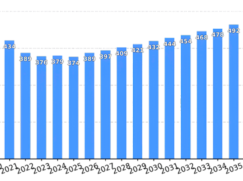
Global consumption
of iron ore (in million tons),
2021–2035